You are here
BC on Track to Set New Temperature Record in 2016
Update, January 2017: The article below has been updated to reflect new observational data for the province. As we had initially suspected, owing to a combination of ongoing anthropogenic climate change and a strong El Niño, 2016 is one of the two warmest years on record for the province as a whole. Though 2016 was very slightly warmer than 2015 overall, a difference of only about a tenth of a degree separates the two years, which is smaller than the uncertainty in the temperature measurements.
|
The very strong El Nino of 2014-2016 helped to deliver a record-warm 2015 in British Columbia last year. Here we analyze the temperature data to see if ongoing climate change along with continued tropical warming was sufficient to set a new record for 2016. Compared with 2015’s fires and scorching summer heat waves, 2016 appeared moderate. Dry conditions and low snow packs lead to an early start to the fire season with Alberta’s Fort McMurray fires capturing the world’s attention in spring but then the fire season quieted, copious summer rains fell, and record heat became less noticeable. By early December, British Columbia was locked in the grips of an arctic air mass the likes of which hadn’t been seen in the province for several years. Yet, an analysis of temperature measurements shows that 2016 is on course to be at least the second and possibly the warmest year on record for British Columbia. Interestingly, warm nights (Fig. 1) were a primary contributor to the temperatures that were experienced.
|
|
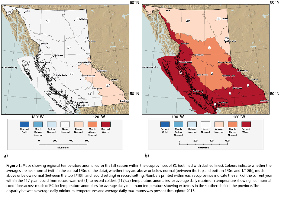
| Figure 1: Maps showing regional temperature anomalies for the fall season within the ecoprovinces of BC (outlined with dashed lines). Colours indicate whether the averages are near normal (within the central 1/3rd of the data), whether they are above or below normal (between the top and bottom 1/3rd and 1/10th), much above or below normal (between the top 1/10th and record setting) or record setting. Numbers printed within each ecoprovince indicate the rank of the current year within the 117 year record from record warmest (1) to record coldest (117). a) Temperature anomalies for average daily maximum temperature showing near normal conditions across much of BC. b) Temperature anomalies for average daily minimum temperature showing extremes in the southern half of the province. The disparity between average daily minimum temperatures and average daily maximums was present throughout 2016. See a larger version. |
To investigate these conditions, temperature and precipitation data gathered from BC provincial ministries, BC Hydro and Environment Canada were analyzed to compare monthly and seasonal averages for the 1900 through 2016 period against the long-term averages from the period 1971-2000. We then combine the monthly and seasonal departures from normal among the eco-provinces of BC to determine a regional look at the magnitude of the anomalies. Specifically, this analysis is of the average of minimum and maximum daily temperature as well as precipitation totals. The departure from normal can be characterized by both the absolute value of the anomaly -- such as the number of degrees Centigrade above or below normal as well as within the context of the long-term record through ranking and percentile which help indicate how frequently or infrequently such events have occurred in the past. The latter approach was chosen. Those results are presented as coloured maps that show record-breaking, top and bottom 10%, top, bottom and middle thirds of all years for a given season or month.
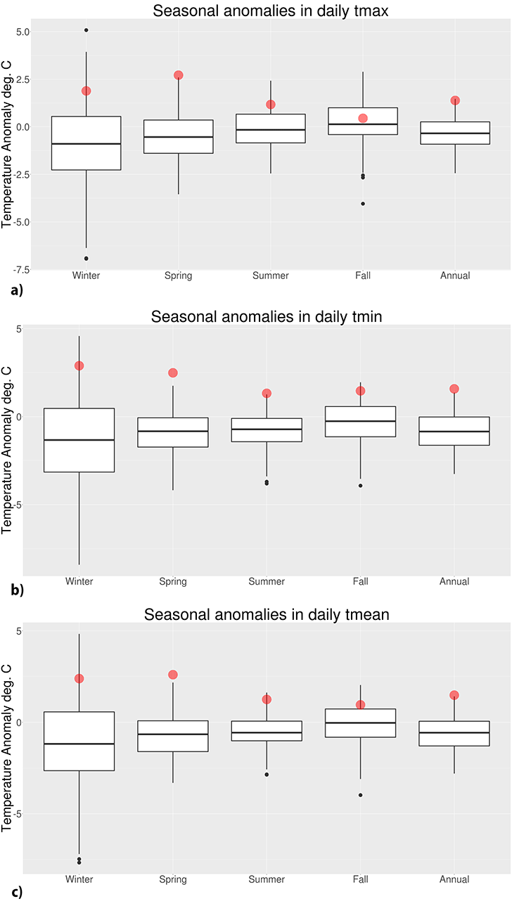
The overall story is that among all regions, at least one record for high temperature was broken in each season. The exception being winter (which spans December 2015 through February 2016) where all regions experienced average daily minimum temperatures in the top 10 percent and all but the south-central and east central portions of the province experienced maximum temperatures in the top 10 percent. Elsewhere, wintertime daily maximum temperatures were in the top third. Warm anomalies increased into spring (Fig. 1) resulting in numerous regional records for average daily minimum and maximum. In fact, only the northeast part of the province escaped record setting seasonal heat, yet that region still experienced daily minimum temperatures that were the second warmest and daily maximum temperatures that were the in the top ten in the long-term record. Summer continued the pattern in which the daytime maximum temperatures were generally above normal, but not exceptional while nighttime low temperatures were record breaking in regions across the north and west of the province. The month of July was extreme in this regard. Daily maximum temperatures were below normal in the south east and near normal almost everywhere else except in the north and northeast part of the province where temperatures were above normal. Minimum temperatures were far more extreme and displayed a pattern of above normal conditions in the southeast ranging to record breaking in the west and northwest portion of BC. The entire season of fall demonstrated the same disparity between daily maximum and minimum temperatures, but with the pattern shifted so that the southern tier of BC experienced the record daily minimums. Daily maximum temperatures were near normal throughout almost all of BC. Within this season, some of the coolest monthly average daily maximum temperatures of the year (relative to normal) were recorded. September average daily maximums were close to normal or below normal in some locations while October brought very cold conditions in northern BC with average daily maximum temperatures in the coldest ten percent of the long-term record and daily minimum temperatures below normal. Despite this two month return to more typical conditions, November marked a return to the pattern established earlier in the year with record breaking minimum temperatures and above normal to much above normal daily maximums. A plot showing the variability within seasons over the 117 years of record that highlights where the 2016 averages fall is given in Figure 2. This figure illustrates that spring was record-breaking for average daily minimum, maximum and mean temperature. For average daily minimum temperature, records were set in spring and summer and temperatures were well within the top 25% for the other two seasons.
|
|
| Figure 2: Plots showing the distribution of 117 years of seasonally averaged and annual temperature anomalies in British Columbia for a) average daily maximum temperature, b) average daily minimum temperature, and c) average daily mean temperature. The data are presented as “box and whisker” plots which show the median temperature anomaly (bold, horizontal line), the range containing 50% of the data (white box) and the range containing 95% of the data (light vertical lines). The box and whisker plots are based on data from 1900 through 2015. The black points are outliers from a normal distribution. The averages (for each season or annually, as labeled) from 2016 are shown as red, semitransparent points. The anomalies are calculated against the 1971 – 2000 long-term mean, so seasons with median values below zero indicate that the bulk of years had cooler temperatures than the long-term mean period. Overall, all seasonal means of daily maximum, minimum, and mean temperature were warmer than at least 75% of the previous data with the exception of fall maximum temperature. |
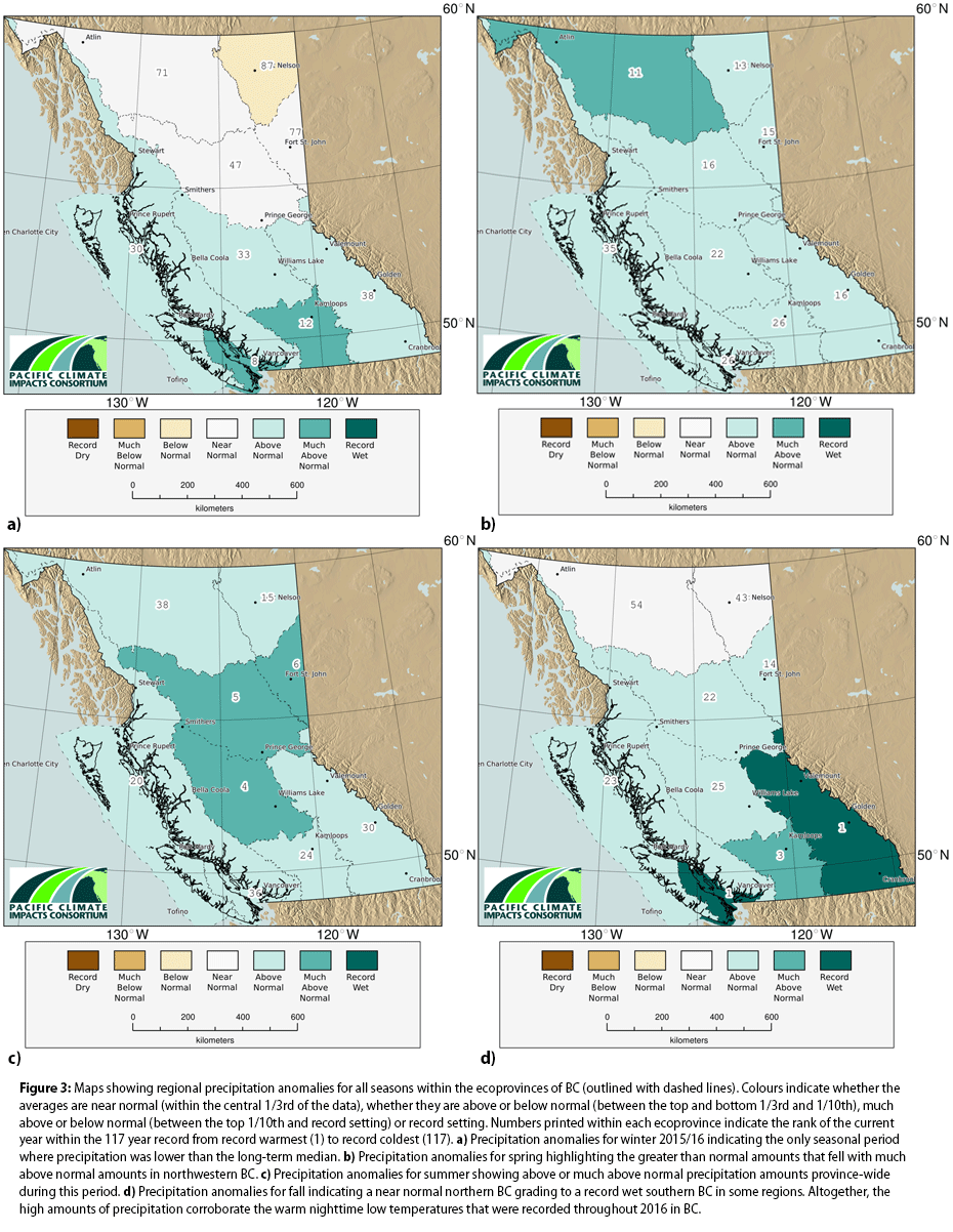
The observed persistent pattern of warm minimum temperatures points to more clouds. Cloudy skies in all seasons, but especially in winter, spring and fall, enable warm nighttime temperatures. Cloud cover reduces the earth’s ability to release heat and during the colder season, clouds are typically associated with warm, moist air masses that promote warm temperatures. Of course with more clouds than normal, one might expect more rain or snow and this is exactly what was observed throughout the year (Fig. 3). On a seasonal basis, only winter and only the northeast of BC showed drier than normal conditions. The remainder of the seasons across the entire province brought normal to much above normal precipitation amounts while fall brought record breaking precipitation to some southern areas of BC. It’s important to point out that seasonal averages may contain shorter term conditions that oppose the seasonal norm. Northeast BC experienced a dry winter with low snow packs and these conditions are revealed as below normal to much below normal precipitation amounts in January and March (seasonal values are shown in Figure 3a). However, even at the monthly timescale, much of the remainder of BC experienced wetter than normal weather month after month throughout 2016.
This brings us to the question posed at the top: did BC experience a record-breaking warm year? Despite the early fire season in the northeast, much of the spring and summer was wet and daytime high temperatures weren’t extremely warm, so it may not have “felt” like a record year. However, continual record to near-record minimum temperatures played a major role in establishing 2016 as an overall warm year. As of the end of November, 2016 is on track to break the previous record set only last year by a margin of 0.23 degrees. If December is a normal or even a slightly cool month, the record will be broken. Interestingly, however, December so far has been quite cold so we cannot be certain that the effects of the month won’t counter the January to November average. If December is warmer than 2.8 degrees below average 2016 will be the warmest year on record. If December falls from 6.9 to 2.8 degrees colder than normal, then 2016 will be the second warmest year on record for BC. The most recent December with a cold anomaly colder than 2.8 degrees was in 2009, so this isn’t a difficult hurdle to cross in our current climate, but we do not yet have the data to be certain. Achieving a December that is colder than 6.9 degrees below normal is much more challenging. There are only three Decembers in the record with a temperature anomaly colder than 6.9 degrees below normal -- 1933, 1927 and 1917 at 10.4, 7.6, and 10.1 degrees below normal respectively. Given that the December, 2016 cold snap wasn’t as extreme as conditions in those years and that temperatures returned to near-normal mid-month and look to remain there in long-term forecasts, it’s unlikely that December, 2016 will hit the -6.9 degree mark. So, it seems likely that 2016 will be at least the second warmest year on record.
|
|
| Figure 3: Maps showing regional precipitation anomalies for all seasons within the ecoprovinces of BC (outlined with dashed lines). Colours indicate whether the averages are near normal (within the central 1/3rd of the data), whether they are above or below normal (between the top and bottom 1/3rd and 1/10th), much above or below normal (between the top 1/10th and record setting) or record setting. Numbers printed within each ecoprovince indicate the rank of the current year within the 117 year record from record warmest (1) to record coldest (117). a) Precipitation anomalies for winter 2015/16 indicating the only seasonal period where precipitation was lower than the long-term median. b) Precipitation anomalies for spring highlighting the greater than normal amounts that fell with much above normal amounts in northwestern BC. c) Precipitation anomalies for summer showing above or much above normal precipitation amounts province-wide during this period. d) Precipitation anomalies for fall indicating a near normal northern BC grading to a record wet southern BC in some regions. Altogether, the high amounts of precipitation corroborate the warm nighttime low temperatures that were recorded throughout 2016 in BC. See a larger version. |
How about when looking at average daily minimum and maximum temperatures individually? As mentioned previously, minimum daily temperatures were more extreme than maximum daily temperatures throughout 2016 yet maximum daily temperatures were also on track to be record breaking. The margin for that record is small so a December average of daily maximum temperatures of 0.17 degrees below normal would be sufficient to prevent the record from breaking. To come in second, the margin is similarly small with a December anomaly of only 1.33 degrees needed. We only need to go back to 2012 to see a cold anomaly stronger than that requirement. For minimum temperatures, a record 2016 is much more likely. To prevent a record from breaking, a December cold anomaly of 5.6 degrees is needed and to prevent 2016 from taking second place, a cold anomaly of 9.8 degrees would be needed. The former threshold was most recently crossed in 1984 with an anomaly of 6.0 degrees. The 9.8 degree threshold has only been crossed twice since 1900 and most recently in 1933. So, for the record for annual average of daily minimum temperature to fail to be broken, December would need to have colder minimum temperatures than any time in the past 32 years. Because the relatively moderate early December cold-snap has dissipated, neither threshold is likely to be crossed which will make 2016 the second warmest year on record overall and the warmest ever for annual average of daily minimum temperatures.
-Faron Anslow, Climatologist and Lead, Climate Analysis and Monitoring Theme
 Twitter
 Facebook
 Google
 LinkedIn