You are here
BC Sees Reflection in Alberta Flood
The rainy season in the southern Rocky Mountains of Alberta and British Columbia typically occurs during the months of May through early July and this year has been no exception. From the 19th of June through the 21st, a slow moving low pressure system tapped into tropical moisture from the Gulf of Mexico and delivered extreme rainfall to the foothills and front ranges of the Rocky Mountains. Heavy rainfall was centred just east of Canmore, AB and extended roughly 100 km to the north and south. As a result of this precipitation event, discharge records were broken for the Bow and Elbow rivers, Calgary and many smaller communities experienced extensive flooding, more than a hundred thousand people were displaced, and major highway infrastructure was damaged throughout the mountains and foothills.
In recent years there have been a number of large spring floods in the Rocky Mountains. In late June and early July, 2011 a storm similar to the one that affected Alberta impacted the more sparsely populated northeast of British Columbia. During June, 2012 heavy precipitation over a two-week period impacted the British Columbia interior leading to extensive flooding and damage.
The Event
Conditions leading up to the event can be summed up as ‘average’. Streamflow and soil conditions were close to normal. The Bow River was on the higher side of its normal range, but nowhere near flood stage and only minor amounts of precipitation had fallen in the southern Rocky Mountain front ranges in the preceding weeks. High elevations still hosted some snow and soils remained frozen in some areas. Furthermore, the storm was very typical of the type of event that brings rainfall to the region during the spring rainy season. A low-pressure centre (which circulates air and moisture in a counter-clockwise direction) tracked to the south and brought moisture around from the southeast, across the top of the system and into the front ranges in a north-easterly to south-westerly flow direction. The major differentiating factors of this event included large amounts of moisture available, strong atmospheric instability, and a perfect orientation to the front ranges of the Rocky Mountains. The orientation of the flow and instability enabled strong uplift which lead to high precipitation rates as the moisture laden air lifted and cooled. The storm also moved slowly which enabled it to deliver a sustained stream of moisture. Likely aggravating factors included snowmelt from the warm temperatures of the event and already-saturated soils from heavy rains several weeks earlier.
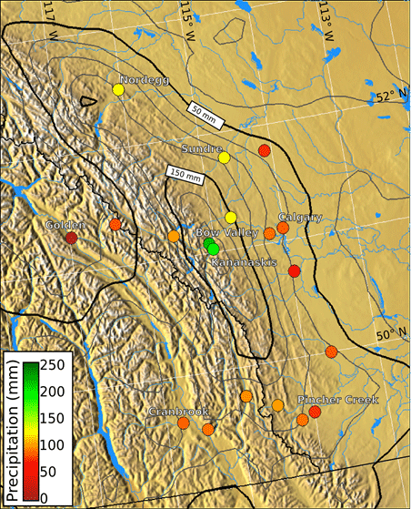
Preliminary one day and four day rainfall totals for the period are summarized in Table 1 and depicted in Figure 1. The data show a bulls-eye of one day precipitation amounts greater than 150 mm in the northern part of Kananaskis Provincial Park, which exceeds the estimated 100 year event for that location1. Nearby Bow Valley experienced more than 110 mm of rain in a single day. Data from the Canadian Precipitation Analysis produced by Environment Canada indicate a swath of such high precipitation amounts running from Nordegg, AB south to near Crowsnest Pass, AB.
Table 1: Summary of precipitation data from the Rocky Mountain front ranges and stations in the southeast interior region of BC (data courtesy Environment Canada).
| Station Name | Lat./Lon. (°N/°E) |
Elevation (m) | Environment Canada ID | One-Day Total (mm) | 19th-22nd Total (mm) |
| Bow Valley | 51.08/-115.07 | 1297.5 | 3050778 | 110.5 | 221.2 |
| Kananaskis | 51.03/-115.03 | 1391.1 | 3053600 | 157.0 | 267.4 |
| Sundre | 51.78/-114.68 | 1114 | 3026KNQ | 81.4 | 124.4 |
| Calgary | 51.11/-114.02 | 1084 | 3031092 | 45.0 | 76.4 |
| Yoho Lake O’hara | 51.36/-116.34 | 2045 | 117R00H | 36.4 | 73.4 |
| Golden A | 51.30/-116.98 | 784.9 | 1173210 | 3.2 | 6.8 |
| Cranbrook | 49.61/-115.78 | 940 | 1152105 | 40.6 | 80.0 |
| Nordegg | 52.49/-116.04 | 1352 | 3054843 | 72.6 | 126.0 |
| Pincher Creek | 49.52/-114.00 | 1189.6 | 3035198 | 32.5 | 65.2 |
All of that water led to broken streamflow records and major flooding of the Bow and Elbow Rivers as well as other tributary streams and rivers. Although the historical record suggests that higher flows occurred at least twice in the late 19th century, the 2013 event was the highest ever reliably measured.
British Columbia also experienced substantial impacts from the storm. Precipitation and streamflow measurements indicate that the event was a 1 in 50 year to 1 in 100 year event in many locations in south-east British Columbia, and numerous streamflow records were broken.
Figure 1: Map of southwest Alberta and southeast BC depicting four-day rainfall totals from the 19th through the 22nd of June, 2013. Contours are rainfall totals from the Canadian Precipitation Analysis, which combines weather model output with station measurements to estimate regional precipitation amounts. Bold contours have a 100 mm interval. Light contours have a 50 mm interval. Coloured dots indicate total precipitation amounts from individual observation stations. Values greater than 200 mm in four days were measured in the Bow Valley in the front ranges of the Rocky Mountains. High precipitation amounts occurred in the western prairies as well as the interior ranges of southeast BC (data courtesy of Environment Canada).
The BC connection
We highlight this event, directed toward PCIC’s audience of British Columbians, because events like this have happened here recently and will happen here again. The dynamics of this storm were almost identical to that which led to flooding and infrastructure damage in June and July of 2011 in the Pine Pass/Chetwynd region of northeast BC. In that case, a similar slow-moving low pressure system brought moisture from the Gulf of Mexico against the front ranges of the northern Rocky Mountains leading to record breaking precipitation totals and flooding.
Roughly one half of the Rocky Mountain front ranges lie in northern British Columbia and have the potential to receive a similar storm. Much of that region hosts natural resources that are being developed or are under consideration for development. These factors point to a need for planners to account for such rainfall events as housing and infrastructure development occurs in this region, and for the possibility that the intensity and frequency of such events might change in the future as the climate continues to warm.
1Based on intensity-duration-frequency analyses from Environment Canada.
 Twitter
 Facebook
 Google
 LinkedIn